|
| at: |
Bienville National Forest |
Data from USFS GIS
 show on map
 animate
Trail users:


Elevation Profile
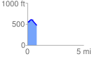
 0.813511 mi
 60.96 ft
 152.53 ft
 -91.57 ft
 3.55 %
GPX Downloads: Track Route
![]()
|
| at: |
Bienville National Forest |
show on map
animate
0.813511 mi
60.96 ft
152.53 ft
-91.57 ft
3.55 %