| at: |
Bienville National Forest |
Data from USFS GIS
 show on map
 animate
Trail users:


Elevation Profile
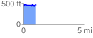
 1.041936 mi
 145.75 ft
 108.20 ft
 37.54 ft
 2.65 %
GPX Downloads: Track Route
![]()
| at: |
Bienville National Forest |
show on map
animate
1.041936 mi
145.75 ft
108.20 ft
37.54 ft
2.65 %