|
| at: |
Bienville National Forest |
Data from USFS GIS
 show on map
 animate
Trail users:


Elevation Profile
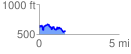
 1.662261 mi
 294.92 ft
 334.89 ft
 -39.97 ft
 3.82 %
GPX Downloads: Track Route
![]()
|
| at: |
Bienville National Forest |
show on map
animate
1.662261 mi
294.92 ft
334.89 ft
-39.97 ft
3.82 %