|
| at: |
Bienville National Forest |
Data from USFS GIS
 show on map
 animate
Trail users:


Elevation Profile
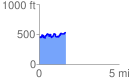
 1.663989 mi
 305.20 ft
 227.33 ft
 77.87 ft
 3.47 %
GPX Downloads: Track Route
![]()
|
| at: |
Bienville National Forest |
show on map
animate
1.663989 mi
305.20 ft
227.33 ft
77.87 ft
3.47 %