|
| at: |
Bienville National Forest |
Data from USFS GIS
 show on map
 animate
Trail users:


Elevation Profile
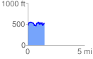
 1.484013 mi
 276.94 ft
 218.35 ft
 58.59 ft
 3.53 %
GPX Downloads: Track Route
![]()
|
| at: |
Bienville National Forest |
show on map
animate
1.484013 mi
276.94 ft
218.35 ft
58.59 ft
3.53 %