|
| at: |
Bienville National Forest |
Data from USFS GIS
 show on map
 animate
Trail users:


Elevation Profile
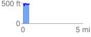
 0.543822 mi
 89.92 ft
 84.69 ft
 5.23 ft
 3.13 %
GPX Downloads: Track Route
![]()
|
| at: |
Bienville National Forest |
show on map
animate
0.543822 mi
89.92 ft
84.69 ft
5.23 ft
3.13 %