|
| at: |
DeSoto National Forest - Chickasawhay District |
Data from USFS GIS
 show on map
 animate
Trail users:


Elevation Profile
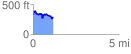
 1.175748 mi
 203.99 ft
 238.29 ft
 -34.30 ft
 3.84 %
GPX Downloads: Track Route
![]()
|
| at: |
DeSoto National Forest - Chickasawhay District |
show on map
animate
1.175748 mi
203.99 ft
238.29 ft
-34.30 ft
3.84 %