| at: |
DeSoto National Forest - Chickasawhay District |
Data from USFS GIS
 show on map
 animate
Trail users:


Elevation Profile
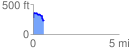
 0.647342 mi
 123.96 ft
 157.46 ft
 -33.51 ft
 4.61 %
GPX Downloads: Track Route
![]()
| at: |
DeSoto National Forest - Chickasawhay District |
show on map
animate
0.647342 mi
123.96 ft
157.46 ft
-33.51 ft
4.61 %