|
| at: |
DeSoto National Forest - Chickasawhay District |
Data from USFS GIS
 show on map
 animate
Trail users:


Elevation Profile
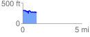
 1.159717 mi
 116.37 ft
 187.28 ft
 -70.92 ft
 3.06 %
GPX Downloads: Track Route
![]()
|
| at: |
DeSoto National Forest - Chickasawhay District |
show on map
animate
1.159717 mi
116.37 ft
187.28 ft
-70.92 ft
3.06 %