| at: |
DeSoto National Forest - Chickasawhay District |
Data from USFS GIS
 show on map
 animate
Trail users:


Elevation Profile
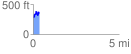
 0.356384 mi
 143.24 ft
 76.46 ft
 66.79 ft
 7.61 %
GPX Downloads: Track Route
![]()
| at: |
DeSoto National Forest - Chickasawhay District |
show on map
animate
0.356384 mi
143.24 ft
76.46 ft
66.79 ft
7.61 %