| at: |
DeSoto National Forest - Chickasawhay District |
Data from USFS GIS
 show on map
 animate
Trail users:


Elevation Profile
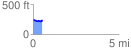
 0.539472 mi
 32.34 ft
 76.47 ft
 -44.14 ft
 2.68 %
GPX Downloads: Track Route
![]()
| at: |
DeSoto National Forest - Chickasawhay District |
show on map
animate
0.539472 mi
32.34 ft
76.47 ft
-44.14 ft
2.68 %