| at: |
DeSoto National Forest - Chickasawhay District |
Data from USFS GIS
 show on map
 animate
Trail users:


Elevation Profile
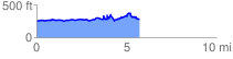
 5.770880 mi
 573.50 ft
 537.68 ft
 35.82 ft
 1.88 %
GPX Downloads: Track Route
![]()
| at: |
DeSoto National Forest - Chickasawhay District |
show on map
animate
5.770880 mi
573.50 ft
537.68 ft
35.82 ft
1.88 %