|
| at: |
DeSoto National Forest - Chickasawhay District |
Data from USFS GIS
 show on map
 animate
Trail users:


Elevation Profile
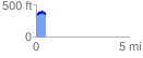
 0.516328 mi
 105.94 ft
 112.62 ft
 -6.68 ft
 4.13 %
GPX Downloads: Track Route
![]()
|
| at: |
DeSoto National Forest - Chickasawhay District |
show on map
animate
0.516328 mi
105.94 ft
112.62 ft
-6.68 ft
4.13 %