| at: |
DeSoto National Forest - Chickasawhay District |
Data from USFS GIS
 show on map
 animate
Trail users:


Elevation Profile
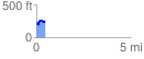
 0.453626 mi
 132.11 ft
 66.36 ft
 65.75 ft
 5.52 %
GPX Downloads: Track Route
![]()
| at: |
DeSoto National Forest - Chickasawhay District |
show on map
animate
0.453626 mi
132.11 ft
66.36 ft
65.75 ft
5.52 %