|
| at: |
DeSoto National Forest - Chickasawhay District |
Data from USFS GIS
 show on map
 animate
Trail users:


Elevation Profile
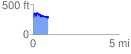
 0.899918 mi
 198.68 ft
 163.57 ft
 35.11 ft
 4.18 %
GPX Downloads: Track Route
![]()
|
| at: |
DeSoto National Forest - Chickasawhay District |
show on map
animate
0.899918 mi
198.68 ft
163.57 ft
35.11 ft
4.18 %