|
| at: |
DeSoto National Forest - Chickasawhay District |
Data from USFS GIS
 show on map
 animate
Trail users:


Elevation Profile
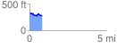
 0.812682 mi
 47.35 ft
 101.79 ft
 -54.44 ft
 2.37 %
GPX Downloads: Track Route
![]()
|
| at: |
DeSoto National Forest - Chickasawhay District |
show on map
animate
0.812682 mi
47.35 ft
101.79 ft
-54.44 ft
2.37 %