| at: |
DeSoto National Forest - Chickasawhay District |
Data from USFS GIS
 show on map
 animate
Trail users:


Elevation Profile
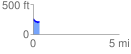
 0.367747 mi
 14.05 ft
 56.22 ft
 -42.17 ft
 2.90 %
GPX Downloads: Track Route
![]()
| at: |
DeSoto National Forest - Chickasawhay District |
show on map
animate
0.367747 mi
14.05 ft
56.22 ft
-42.17 ft
2.90 %