| at: |
DeSoto National Forest - Chickasawhay District |
Data from USFS GIS
 show on map
 animate
Trail users:


Elevation Profile
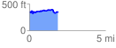
 1.901532 mi
 239.84 ft
 251.61 ft
 -11.77 ft
 2.51 %
GPX Downloads: Track Route
![]()
| at: |
DeSoto National Forest - Chickasawhay District |
show on map
animate
1.901532 mi
239.84 ft
251.61 ft
-11.77 ft
2.51 %