|
| at: |
DeSoto National Forest - Chickasawhay District |
Data from USFS GIS
 show on map
 animate
Trail users:


Elevation Profile
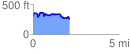
 2.136516 mi
 302.86 ft
 362.99 ft
 -60.13 ft
 3.22 %
GPX Downloads: Track Route
![]()
|
| at: |
DeSoto National Forest - Chickasawhay District |
show on map
animate
2.136516 mi
302.86 ft
362.99 ft
-60.13 ft
3.22 %