| at: |
DeSoto National Forest - Chickasawhay District |
Data from USFS GIS
 show on map
 animate
Trail users:


Elevation Profile
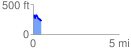
 0.488543 mi
 78.25 ft
 165.18 ft
 -86.94 ft
 6.40 %
GPX Downloads: Track Route
![]()
| at: |
DeSoto National Forest - Chickasawhay District |
show on map
animate
0.488543 mi
78.25 ft
165.18 ft
-86.94 ft
6.40 %