| at: |
DeSoto National Forest - Chickasawhay District |
Data from USFS GIS
 show on map
 animate
Trail users:


Elevation Profile
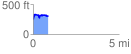
 0.886381 mi
 167.45 ft
 136.71 ft
 30.74 ft
 3.58 %
GPX Downloads: Track Route
![]()
| at: |
DeSoto National Forest - Chickasawhay District |
show on map
animate
0.886381 mi
167.45 ft
136.71 ft
30.74 ft
3.58 %