| at: |
DeSoto National Forest - Chickasawhay District |
Data from USFS GIS
 show on map
 animate
Trail users:


Elevation Profile
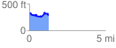
 1.271177 mi
 212.36 ft
 255.53 ft
 -43.17 ft
 3.81 %
GPX Downloads: Track Route
![]()
| at: |
DeSoto National Forest - Chickasawhay District |
show on map
animate
1.271177 mi
212.36 ft
255.53 ft
-43.17 ft
3.81 %