| at: |
DeSoto National Forest - Chickasawhay District |
Data from USFS GIS
 show on map
 animate
Trail users:


Elevation Profile
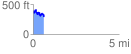
 0.637166 mi
 183.23 ft
 243.07 ft
 -59.84 ft
 7.23 %
GPX Downloads: Track Route
![]()
| at: |
DeSoto National Forest - Chickasawhay District |
show on map
animate
0.637166 mi
183.23 ft
243.07 ft
-59.84 ft
7.23 %