| at: |
DeSoto National Forest - Chickasawhay District |
Data from USFS GIS
 show on map
 animate
Trail users:


Elevation Profile
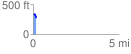
 0.196931 mi
 10.95 ft
 70.58 ft
 -59.63 ft
 6.79 %
GPX Downloads: Track Route
![]()
| at: |
DeSoto National Forest - Chickasawhay District |
show on map
animate
0.196931 mi
10.95 ft
70.58 ft
-59.63 ft
6.79 %