| at: |
DeSoto National Forest - Chickasawhay District |
Data from USFS GIS
 show on map
 animate
Trail users:


Elevation Profile
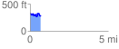
 0.672528 mi
 131.57 ft
 158.00 ft
 -26.43 ft
 4.45 %
GPX Downloads: Track Route
![]()
| at: |
DeSoto National Forest - Chickasawhay District |
show on map
animate
0.672528 mi
131.57 ft
158.00 ft
-26.43 ft
4.45 %