| at: |
DeSoto National Forest - Chickasawhay District |
Data from USFS GIS
 show on map
 animate
Trail users:


Elevation Profile
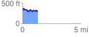
 1.300421 mi
 175.11 ft
 178.05 ft
 -2.94 ft
 2.59 %
GPX Downloads: Track Route
![]()
| at: |
DeSoto National Forest - Chickasawhay District |
show on map
animate
1.300421 mi
175.11 ft
178.05 ft
-2.94 ft
2.59 %