| at: |
DeSoto National Forest - Chickasawhay District |
Data from USFS GIS
 show on map
 animate
Trail users:


Elevation Profile
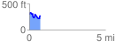
 0.718315 mi
 181.54 ft
 198.84 ft
 -17.29 ft
 5.24 %
GPX Downloads: Track Route
![]()
| at: |
DeSoto National Forest - Chickasawhay District |
show on map
animate
0.718315 mi
181.54 ft
198.84 ft
-17.29 ft
5.24 %