| at: |
DeSoto National Forest - Chickasawhay District |
Data from USFS GIS
 show on map
 animate
Trail users:


Elevation Profile
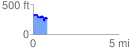
 0.834091 mi
 122.18 ft
 163.13 ft
 -40.95 ft
 3.70 %
GPX Downloads: Track Route
![]()
| at: |
DeSoto National Forest - Chickasawhay District |
show on map
animate
0.834091 mi
122.18 ft
163.13 ft
-40.95 ft
3.70 %