|
| at: |
DeSoto National Forest - Chickasawhay District |
Data from USFS GIS
 show on map
 animate
Trail users:


Elevation Profile
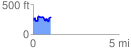
 1.049250 mi
 261.61 ft
 206.08 ft
 55.53 ft
 4.72 %
GPX Downloads: Track Route
![]()
|
| at: |
DeSoto National Forest - Chickasawhay District |
show on map
animate
1.049250 mi
261.61 ft
206.08 ft
55.53 ft
4.72 %