| at: |
DeSoto National Forest - Chickasawhay District |
Data from USFS GIS
 show on map
 animate
Trail users:


Elevation Profile
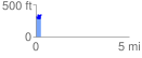
 0.272567 mi
 128.09 ft
 87.93 ft
 40.16 ft
 8.90 %
GPX Downloads: Track Route
![]()
| at: |
DeSoto National Forest - Chickasawhay District |
show on map
animate
0.272567 mi
128.09 ft
87.93 ft
40.16 ft
8.90 %