| at: |
DeSoto National Forest - Chickasawhay District |
Data from USFS GIS
 show on map
 animate
Trail users:


Elevation Profile
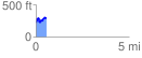
 0.593514 mi
 166.87 ft
 94.28 ft
 72.60 ft
 5.33 %
GPX Downloads: Track Route
![]()
| at: |
DeSoto National Forest - Chickasawhay District |
show on map
animate
0.593514 mi
166.87 ft
94.28 ft
72.60 ft
5.33 %