|
| at: |
DeSoto National Forest - Chickasawhay District |
Data from USFS GIS
 show on map
 animate
Trail users:


Elevation Profile
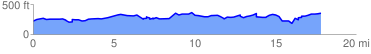
 18.011439 mi
 2200.98 ft
 2119.32 ft
 81.66 ft
 2.31 %
GPX Downloads: Track Route
![]()
|
| at: |
DeSoto National Forest - Chickasawhay District |
show on map
animate
18.011439 mi
2200.98 ft
2119.32 ft
81.66 ft
2.31 %