| at: |
DeSoto National Forest - Chickasawhay District |
Data from USFS GIS
 show on map
 animate
Trail users:


Elevation Profile
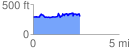
 2.742125 mi
 382.18 ft
 393.38 ft
 -11.20 ft
 2.72 %
GPX Downloads: Track Route
![]()
| at: |
DeSoto National Forest - Chickasawhay District |
show on map
animate
2.742125 mi
382.18 ft
393.38 ft
-11.20 ft
2.72 %