| at: |
DeSoto National Forest - Chickasawhay District |
Data from USFS GIS
 show on map
 animate
Trail users:


Elevation Profile
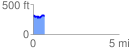
 0.652884 mi
 105.36 ft
 104.64 ft
 0.72 ft
 3.06 %
GPX Downloads: Track Route
![]()
| at: |
DeSoto National Forest - Chickasawhay District |
show on map
animate
0.652884 mi
105.36 ft
104.64 ft
0.72 ft
3.06 %