|
| at: |
DeSoto National Forest - Chickasawhay District |
Data from USFS GIS
 show on map
 animate
Trail users:


Elevation Profile
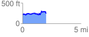
 2.054170 mi
 271.95 ft
 241.01 ft
 30.94 ft
 2.51 %
GPX Downloads: Track Route
![]()
|
| at: |
DeSoto National Forest - Chickasawhay District |
show on map
animate
2.054170 mi
271.95 ft
241.01 ft
30.94 ft
2.51 %