| at: |
DeSoto National Forest - Chickasawhay District |
Data from USFS GIS
 show on map
 animate
Trail users:


Elevation Profile
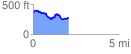
 2.115561 mi
 242.65 ft
 323.86 ft
 -81.20 ft
 2.90 %
GPX Downloads: Track Route
![]()
| at: |
DeSoto National Forest - Chickasawhay District |
show on map
animate
2.115561 mi
242.65 ft
323.86 ft
-81.20 ft
2.90 %