| at: |
DeSoto National Forest - Chickasawhay District |
Data from USFS GIS
 show on map
 animate
Trail users:


Elevation Profile
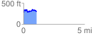
 1.074388 mi
 200.60 ft
 179.95 ft
 20.65 ft
 3.54 %
GPX Downloads: Track Route
![]()
| at: |
DeSoto National Forest - Chickasawhay District |
show on map
animate
1.074388 mi
200.60 ft
179.95 ft
20.65 ft
3.54 %