|
| at: |
DeSoto National Forest - Chickasawhay District |
Data from USFS GIS
 show on map
 animate
Trail users:


Elevation Profile
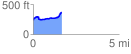
 1.689179 mi
 220.27 ft
 98.71 ft
 121.56 ft
 2.47 %
GPX Downloads: Track Route
![]()
|
| at: |
DeSoto National Forest - Chickasawhay District |
show on map
animate
1.689179 mi
220.27 ft
98.71 ft
121.56 ft
2.47 %