|
| at: |
DeSoto National Forest - Chickasawhay District |
Data from USFS GIS
 show on map
 animate
Trail users:


Elevation Profile
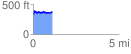
 1.132896 mi
 156.58 ft
 111.62 ft
 44.96 ft
 2.62 %
GPX Downloads: Track Route
![]()
|
| at: |
DeSoto National Forest - Chickasawhay District |
show on map
animate
1.132896 mi
156.58 ft
111.62 ft
44.96 ft
2.62 %