| at: |
DeSoto National Forest - Chickasawhay District |
Data from USFS GIS
 show on map
 animate
Trail users:


Elevation Profile
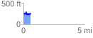
 0.585966 mi
 112.93 ft
 157.35 ft
 -44.42 ft
 5.09 %
GPX Downloads: Track Route
![]()
| at: |
DeSoto National Forest - Chickasawhay District |
show on map
animate
0.585966 mi
112.93 ft
157.35 ft
-44.42 ft
5.09 %