| at: |
DeSoto National Forest - Chickasawhay District |
Data from USFS GIS
 show on map
 animate
Trail users:


Elevation Profile
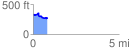
 0.841033 mi
 84.80 ft
 162.47 ft
 -77.68 ft
 3.66 %
GPX Downloads: Track Route
![]()
| at: |
DeSoto National Forest - Chickasawhay District |
show on map
animate
0.841033 mi
84.80 ft
162.47 ft
-77.68 ft
3.66 %