| at: |
DeSoto National Forest - Chickasawhay District |
Data from USFS GIS
 show on map
 animate
Trail users:


Elevation Profile
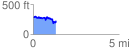
 1.361368 mi
 209.95 ft
 316.65 ft
 -106.70 ft
 4.41 %
GPX Downloads: Track Route
![]()
| at: |
DeSoto National Forest - Chickasawhay District |
show on map
animate
1.361368 mi
209.95 ft
316.65 ft
-106.70 ft
4.41 %