| at: |
DeSoto National Forest - Chickasawhay District |
Data from USFS GIS
 show on map
 animate
Trail users:


Elevation Profile
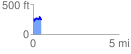
 0.469358 mi
 141.01 ft
 150.20 ft
 -9.20 ft
 6.06 %
GPX Downloads: Track Route
![]()
| at: |
DeSoto National Forest - Chickasawhay District |
show on map
animate
0.469358 mi
141.01 ft
150.20 ft
-9.20 ft
6.06 %