|
| at: |
DeSoto National Forest - Chickasawhay District |
Data from USFS GIS
 show on map
 animate
Trail users:


Elevation Profile
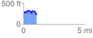
 1.063764 mi
 184.52 ft
 193.03 ft
 -8.51 ft
 3.44 %
GPX Downloads: Track Route
![]()
|
| at: |
DeSoto National Forest - Chickasawhay District |
show on map
animate
1.063764 mi
184.52 ft
193.03 ft
-8.51 ft
3.44 %