|
| at: |
DeSoto National Forest - Chickasawhay District |
Data from USFS GIS
 show on map
 animate
Trail users:


Elevation Profile
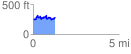
 1.286222 mi
 237.33 ft
 206.33 ft
 31.00 ft
 3.49 %
GPX Downloads: Track Route
![]()
|
| at: |
DeSoto National Forest - Chickasawhay District |
show on map
animate
1.286222 mi
237.33 ft
206.33 ft
31.00 ft
3.49 %