| at: |
DeSoto National Forest - Chickasawhay District |
Data from USFS GIS
 show on map
 animate
Trail users:


Elevation Profile
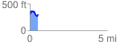
 0.547113 mi
 111.56 ft
 109.88 ft
 1.68 ft
 3.86 %
GPX Downloads: Track Route
![]()
| at: |
DeSoto National Forest - Chickasawhay District |
show on map
animate
0.547113 mi
111.56 ft
109.88 ft
1.68 ft
3.86 %