| at: |
DeSoto National Forest - Chickasawhay District |
Data from USFS GIS
 show on map
 animate
Trail users:


Elevation Profile
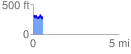
 0.558910 mi
 138.92 ft
 166.86 ft
 -27.94 ft
 5.65 %
GPX Downloads: Track Route
![]()
| at: |
DeSoto National Forest - Chickasawhay District |
show on map
animate
0.558910 mi
138.92 ft
166.86 ft
-27.94 ft
5.65 %