| at: |
DeSoto National Forest - Chickasawhay District |
Data from USFS GIS
 show on map
 animate
Trail users:


Elevation Profile
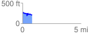
 0.831668 mi
 88.06 ft
 138.98 ft
 -50.92 ft
 3.16 %
GPX Downloads: Track Route
![]()
| at: |
DeSoto National Forest - Chickasawhay District |
show on map
animate
0.831668 mi
88.06 ft
138.98 ft
-50.92 ft
3.16 %