| at: |
DeSoto National Forest - Chickasawhay District |
Data from USFS GIS
 show on map
 animate
Trail users:


Elevation Profile
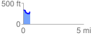
 0.566418 mi
 65.47 ft
 107.62 ft
 -42.15 ft
 3.60 %
GPX Downloads: Track Route
![]()
| at: |
DeSoto National Forest - Chickasawhay District |
show on map
animate
0.566418 mi
65.47 ft
107.62 ft
-42.15 ft
3.60 %