| at: |
DeSoto National Forest - Chickasawhay District |
Data from USFS GIS
 show on map
 animate
Trail users:


Elevation Profile
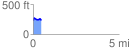
 0.484854 mi
 64.73 ft
 86.90 ft
 -22.17 ft
 3.39 %
GPX Downloads: Track Route
![]()
| at: |
DeSoto National Forest - Chickasawhay District |
show on map
animate
0.484854 mi
64.73 ft
86.90 ft
-22.17 ft
3.39 %